
 Between the year 1665 and 1670 sandstorms took place which threatened to overwhelm the village of Santon Downham and silted up the river between Thetford and Brandon. The following is an interpretation of an account given in a letter by Thomas Wright Esq. to The Royal Society in 1668. He was living in Santon Downham at the time. He said that he found some difficulty in tracing these wonderful sands to their origin, but he found it to be in a warren in Lakenheath; a town about five miles south-west of Santon Downham. Here some great sand hills broken by the tempestuous south-west winds were blown upon some adjacent ground. This being of the same nature and having only a thin coat of grass over it, which was soon rotted because of the other sand lying on it.
It joined the Lakenheath sand, increased its mass, and accompanied its strange progress. Mr Wright supposes that at the first eruption the sand did not cover more than eight or ten acres of ground; but before it had travelled four miles from its first abode it increased so much that it covered more than a thousand. All the opposition the sand met with from Lakenheath to Downham was from one farm house. The owner endeavoured to secure this by building bulwarks against the sand; but perceiving this would not answer his purpose he changed his plan. Instead of trying to prevent its approach he removed all the bulwarks and fences so that the sand could have free passage. In four or five years time he was nearly rid of it. It was about thirty or forty years before the writing of this account that the sand reached Downham, where it continued for ten or twelve years in the outskirts of the town without doing considerable damage. The reason for which (Mr Wright imagined) was because its current was then downhill which sheltered it from those winds which gave it motion. The valley being once passed, it went about a mile up hill in two months time, and over-ran about 200 acres of very good corn land the same year.
(Here Mr. Wright goes on to describe the damage caused by the sand in Santon Downham) “It is now got into the body of this little town, where it hath buried and destroyed diverse tenements and other houses and hath forced us to preserve the remainder at a greater expense than they are worth.” Mr. Wright made enormous efforts to save his farmhouse and land, though for four or five years his success was doubtful. The sand had blocked all his avenues so that there was no passage to him, except over two walls that were eight or nine feet high which encompassed a small grove in front of his house. At one time his yard was buried. The sand had blown almost up to the eves of his out houses. At the other end it had broken down his garden wall and stopped all passage that way.
For four or five years Mr.Wright stopped it as well as he could. For month after month, year after year, he constructed furze hedges. As fast as they were overwhelmed he raised fresh ones on top of the others. Eventually he had mighty ramparts some 60 feet in height. Because of these ramparts the sand was confined to a space of nine to ten acres. Into this sand Mr. Wright mixed hundreds of loads of good soil and manure. In one year he had managed to reduce it again to fertile land. He then cleared all his walls, and with the assistance of his neighbours, who helped him cart away1500 loads in a month, he cut a passage to his house through the main body of sand. The other end of the village met with a worse fate where many houses were overthrown or buried.
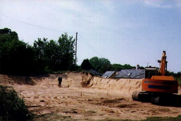
The pastures and meadows, (which for so small a village were considerable), were over-run and destroyed. The river was so full of sand that boats transporting goods between Thetford and Brandon were unable to carrying as much cargo as they had done before. Today there is little evidence of the sand flood in Santon Downham except in Hall Drive, which is believed to be the approach to Mr. Wright’s house. For many years there was a high sand bank on one side .In the latter part of 1999 this bank was partially removed to build a new house.
The sand flood has been the subject of both a Radio programme and Scientific Investigation in recent years.
Reference: Thomas Wright 1668.Philosophical Transactions of the Royal Society of London. 3, 722-725.
Ronnie Moran ©2000
Research By Dr Steve Godby And Dr Mark Bateman
NB – this article was written in 2001 as part of the 22 villages project and as such may no longer be up to date. A paper by the authors was subsequently published in 2004 in the journal The Holocene. Please contact us (or the authors directly) for further information.
Between the large American air field at RAF Lakenheath and Brandon there is a surprising landscape for inland Britain: a system of sand dunes rising up around 6m above the surrounding area. These dunes are best developed at the Wangford Warren SSSI (TL 759841) and sand removed from this area by the wind is believed to have led to the overwhelming of Santon Downham in 1668 as reported by Thomas Wright Esq to the Royal Society. Prior to forestation in the mid-19th century the sand of the area was much more mobile than today and images of the landscape were captured vividly by several author:
John Evelyn, the noted diarist, wrote in 1677 of “….The Travelling Sands, about ten miles wide of Euston, that have so damaged the country, rolling from place to place, and like the sands in the deserts of Libya, quite overwhelmed some gentleman’s whole estates…..”
William Gilpin in 1769 was surprised to find “….such a piece of absolute desert almost in the heart of England” and that “Nothing was to be seen on either side but sand and scattered gravel without the least vegetation; a mere African desert.”
Charles Kidman in 1735 wrote of “the horrible Brandon sands”
As late as 1829 David Davy described the Brandon area of being “….as barren a waste as ever I saw; the soil appears to produce nothing but rabbits and flints for a considerable distance……”
The connection between the dunes at Wangford and the sand flood in Santon Downham in 1668 has yet to be established, as has the cause of the event itself. A team consisting of Dr.Steve Godby from Anglia Polytechnic University in Cambridge and Dr. Mark Bateman of the University of Sheffield are conducting research into the event and its significance. Before adding to the sandstorm story, we need the answer to two questions; where did the sand come from in the first place and why was it on the move?
The sandy soils of Breckland are derived from a deposit known as cover sand. Cover sands are wind-blown deposits that blanket the landscape and are the result of the cold, dry and windy conditions experienced during periglacial conditions. The UK has four known cover sand regions, deposited towards the end of the last glacial episode of ‘Ice Age’ that is known as the Devonian. Sand was potentially supplied for the Breckland area by melts water from the Devonian ice sheet, the exposed bed of the North Sea and the weathering of till or boulder clay from the ice sheet. The cold and windy conditions found in this type of environment, combined with a lack of vegetation, are ideal for the movement sand by the wind. The Breckland cover sand has been dated, from the sand sample collected at Grimes Graves using a technique known as Optically Stimulated Luminescence (OSL) by Dr. Mark Bateman, to 14,000years B.P.( Before Present). This means that the sand was indeed deposited during periglacial conditions towards the end of the Devonian. The implications for the dunes at Wangford are that they could be of a similar age and not connected with the 1668 sand flood. Speculation as to why the sand flood took place in the first place has tended to centre on the roll of the rabbits, mainly based on the information provided by Thomas Wright in his letter to the Royal Society in which he identified Lakenheath Warren as the source area for the sand.
The impact that rabbits through removing vegetation cover and their burrowing may lead to bare ground which the wind can then exploit, yet initial research has suggested that the impact had by rabbits, even in large numbers, may not have been enough to cause such large scale sand migration. Rabbit activities in combination with sheep grazing have much more potential for the removal of vegetation on a large scale and sheep were kept on the warrens at the time of the sand flood. Another factor that may be of great importance is climate. If the vegetation in the area were sparse due to climatic influences such as cold and dry conditions then the wind would be more effective as an erosional agent. 1668 and the preceding years during which the sand flood event took place fall within a period known as the little Ice Age (1550-1850 A.D.), A time of climatic deterioration in Europe and beyond. A focus of the research in the role that climate may have played in the Santon Downham story.
To date our work has centred on establishing the history of the dunes at Wangford Warren. This has involved establishing the age of the dunes using a combination of the OSL technique and radiocarbon dating and has revealed that wind action has been important at the site since at least 6000 years ago and continued until recent years. Detailed examination of the dunes for activity during the sand flood period is now taking place., with early indications suggesting that they are contemporaneous with the event described by Thomas Wright Esq. Other dune sites located between Wangford /Lakenheath Warren and Santon Downham are also being explored and work is set to commence in and around the village itself in the near future. Some dune forms remain in and around Santon Downham (as described by Mr. and Mrs. Moran) and these will be sampled for OSL in order to establish their age. Historical sources are also being investigated in order to establish the land use patterns in the area, with particular regard to the rabbit warrens, during the period.
 The ultimate aim of our research is to fully understand the sand flood event at Santon Downham and why it took place. This information is useful for the future management of the Wangford Warren SSSI and may also be able to give a valuable insight into the climatic conditions prevalent during the event. Given the likelihood of human induced climatic change in the near future, this type of information is of great value for making predictions of environmental change.
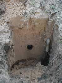
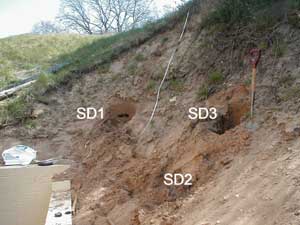 Tubular samples were taken from one of the remaining sand dunes in Santon Downham. The luminescence dating technique was then used to determine when the sand was last disturbed.
 We are very keen to find any historical record that may shed light on the area and the sand flood event. Tracing any maps and paintings of the area would also be very useful. Another interesting question relates to a local legend about St. Mary’s Church in Santon Downham. Approximately 1/3 of the way up on the tower of the church, a red brick is placed amongst the quoin stone and it is claimed that this marks the height to which the sand climbed against the tower! However unlikely that this may seem, we are keen to find out why a solitary brick would be used in such a way in a church tower.
Dr.Steve Godby Dr. Mark Bateman, Department of Geography, SCIDR Anglia Polytechnic University, Department of Geography, East Road, University of Sheffield, Cambridge. CB1 1PT Sheffield Tel: 01223 363171 Ext 2586 S 10 2TN Fax. 01223 352973 Tel. 01142227929 E mail s.p.godby@anglia.ac.uk Fax. 01142797912 Email m.d.bateman@sheffield.ac.uk