![]()
![]()
![]()
![]()
|
|

|
IntroductionThere have been a number of finds unearthed in the parish of Cavenham which suggest this area has been inhabited by man since the Palaeolithic period. Since then the land has been put to many uses, the free range hunting of the Mesolithic period, grazing of the first rather nomadic settlers and finely farming of the Iceni tribes. Most of the earlier finds show activity to the north of Cavenham but there is some doubt as to whether this is the origin of the village itself which is now sited further south of these first archaeological remains. Below we have noted the finds and their sources in the hope of discovering some truth to this theory. Pre - GlacialThe occasional bones and tusks of mammoth and horses have been found on the
heath land which lies to the north of Cavenham village. These finds were
overlaid with silt containing arctic flora presumably washed down by glacial
movement. The variety of hand held axes, ovates and a cleaver found from the
Palaeolithic period have been rolled to varying degrees again suggesting erosion
by the flowing glaciers, these are now cared for in The British Museum. Source
Palaeolithic sites of East Anglia by John Wymer Early SettlersCavenham’s sandy soils have revealed a number of finds which suggest that
tribes probably hunted and gathered in this area with documented evidence of
finds from the Mesolithic and Neolithic periods excavated in the quarries to the
north of Cavenham, above the flood plain Water SourcesWater resources were of critical importance in this area of free draining sandy soil, permanent settlers would have needed easy access to water for their sheep. To the east of today’s village Cavenham’s stream runs from south to north as a tributary of the River Lark. The water level is by no means consistent and just over the last two centuries has dropped considerably. Early maps show a water meadow between the church and stream and archaeologists are investigating a seasonal mere further north of this water meadow. IceniIt is now thought that the boundaries between the tribes of Iceni to the
north and Trinovantes to the south lay in Suffolk. The distribution of coins or
rather the lack of them, in this area suggest that the River Lark and Icknield
Way may have been a part of a political boundary. It is suggested that these
boundaries fluctuated leaving a belt of unoccupied territory between the tribes.
The Black Ditches may have re-enforced this boundary RomanFindspots on Cavenham heath land to the north revealed an array of items from
the Iron Age including the ornate Cavenham crowns and headdress believed to be
Roman, dating from the 2nd Century AD. A later dig identified a very large urn
whose mouth measured 131/2 inches, dated 40 to 80 A.D. and ‘brown -leather’
ware, dated 1 to 50 A.D. Further specimen tiles and fragments of pottery dated
from the 1st to 3rd or 4th century indicate a burial ground. No villa was found
within a 30 yard radius of this dig yet it is considered likely that a homestead
did exist, though probably as part of the large open settlement based, over the
valley, in Icklingham Anglo SaxonThe origin of the name Cavenham stems from the Anglo Saxon word ‘Cafna’
or Cafa, the latter is an Old English noun for ‘bold or active’. At the time
of the Domesday Book the village had been known as ‘Cauanham’; Cauan is the
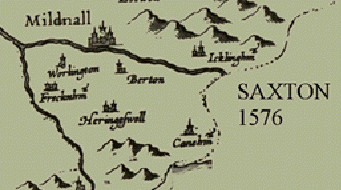
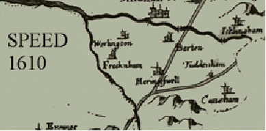
genitive of Caua which should be written as Cafa We might suppose that the Anglo Saxon name Cauaham did not refer to the site on the heath land, the location of many earlier findspots, but to another, further south, near St. Andrew’s church, which is thought to have Anglo Saxon origins. This site is strategically placed near the crossing of the Icknield Way and Cavenham Stream with the Black Ditches directly north and south, protecting ‘Cafna’ from the east. Maps held by The Bury Record Office.1736 by John Kirby shows detailed picture of house with area of land marked Johnson Esq. Village known as Cavenham 1777 Bowden: Village marked as Cavenham. Also marked an area of land ‘Webb Esq’ who was lord of Shardelowe Manor 1779 Shows Thomas Le Blanc as owner Cavenham Park 1783 County map by Joseph Hodskinson showing House in Park 1802 Enclosure map 1836 O.S. map shows a quad of stable blocks with Hall attached
|
|
A Forest Heath District Council (Suffolk) Project supported by the Heritage Lottery Fund as part of the Millennium Festival ©2000 Designed by ArtAtac |