The Stone Bridge
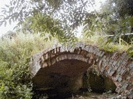 The stone bridge lies unused to the south of Cavenham village adjacent to the
modern bridge on the Cavenham to Lackford road. A humped back bridge over a
tributory of the River Lark it was probably used by packhorses travelling the
Icknield Way.
The stone bridge lies unused to the south of Cavenham village adjacent to the
modern bridge on the Cavenham to Lackford road. A humped back bridge over a
tributory of the River Lark it was probably used by packhorses travelling the
Icknield Way.
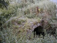 Although known to archeologists and historians, it does not appear to
have been the subject of any detailed investigations. The records of the Suffolk
Archaeology Unit refer to 4 courses of Tudor brickwork and, in an article
written in 1932 it is described as showing traces of parapet walls and dating
from not later than the 15th century. The overall width is 71/2 feet with an
approximate clearance of 5 feet suggests that it came into existence when carts
and wagons first came into general use. A mere five feet, however must have been
a tight squeeze for a loaded wagon and therefore probably constructed to enable
packhorse trains to avoid the ford.
Although known to archeologists and historians, it does not appear to
have been the subject of any detailed investigations. The records of the Suffolk
Archaeology Unit refer to 4 courses of Tudor brickwork and, in an article
written in 1932 it is described as showing traces of parapet walls and dating
from not later than the 15th century. The overall width is 71/2 feet with an
approximate clearance of 5 feet suggests that it came into existence when carts
and wagons first came into general use. A mere five feet, however must have been
a tight squeeze for a loaded wagon and therefore probably constructed to enable
packhorse trains to avoid the ford.
Icknield Way
Ordinance Survey maps mark the road that fords Cavenham stream as that of the
Icknield Way which in previous times was a drovers road for cattle. The Icknield
Way is unique among long distance tracks because it can claim to be the oldest
road in Britain and was already ancient when the Romans came. It has never been
straight or paved like a Roman road but consists of a skein of prehistoric
trackways following chalkland from the Wash to the Dorset coast. Even today,
because of the good drainage, the chalk makes the going easy.
A curious feature of some old roads is the creation of multiple tracks
running in parallel, either where there was nothing to contain the road, as in a
drove road crossing high ground, or where travellers had chosen the easiest
route available, such as when crossing a river.
As a result the Icknield Way is thought once
to have been, in places, a mile wide .
In Cavenham, the swelling and flooding of the River Lark and it’s tributories
would have created obstacles for the grazing cattle, The slowly advancing cattle
would have crossed the heath land in a broad sweep and funnelled to a narrower
column to ford the river at a number of points of which Cavenham’s crossing
was just one.
.
In Cavenham, the swelling and flooding of the River Lark and it’s tributories
would have created obstacles for the grazing cattle, The slowly advancing cattle
would have crossed the heath land in a broad sweep and funnelled to a narrower
column to ford the river at a number of points of which Cavenham’s crossing
was just one.
Finds discovered in 1943-4 in Southfield's to the south of Cavenham suggest
another possible route across the River Lark was to the south probably at or
near today’s Robert’s bridge.
While Christopher Taylor, author of Roads and Tracks of Britain, suggests the
Icknield Way crossed at Temple Bridge to the north of Cavenham village.