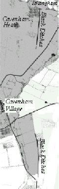
Black Ditches
 The
exact origins of these extensive earthworks, which transverse the Icknield Way
in Cavenham parish, is unknown. Over the years many differing theories have been
put forward but the most probable and more recent explanation for their initial
construction was as an agricultural boundary probably from the time of the Iceni.
As the politics of the area changed they were enlarged to create a boundary
between the Iceni and Trinovantes tribes.
The
exact origins of these extensive earthworks, which transverse the Icknield Way
in Cavenham parish, is unknown. Over the years many differing theories have been
put forward but the most probable and more recent explanation for their initial
construction was as an agricultural boundary probably from the time of the Iceni.
As the politics of the area changed they were enlarged to create a boundary
between the Iceni and Trinovantes tribes.
Prasutagus King of the Iceni and married to the more famous Boadicea was a
‘client- ruler’ whose people traded willingly with the Romans in return
receiving military protection and state funding until his death in 60 AD. The
Trinovantes did not hold the same relationship with the Roman invaders and it is
their relationship with the Iceni or Romans that might have created a need for a
defensive boundary.
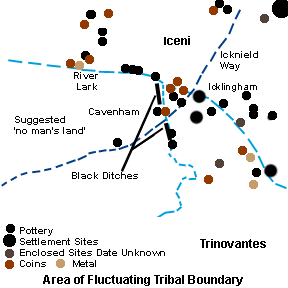 Further
studies of East Anglia point out that a lack of archaeological evidence
particularly the paucity of coins found in a diagonal curve across the counties
would suggest a type of no mans land between the Trinovantes and the Iceni to
their north east. A section of this no mans land ran to the south west of
Icklingham fluctuating around Cavenham.
Further
studies of East Anglia point out that a lack of archaeological evidence
particularly the paucity of coins found in a diagonal curve across the counties
would suggest a type of no mans land between the Trinovantes and the Iceni to
their north east. A section of this no mans land ran to the south west of
Icklingham fluctuating around Cavenham.
Archaeological Investigations
The Black ditches run from north to south breaking at the Icknield Way. The
northern stretch is 1100 yards in length while the southern ditch runs for 1 1/2
miles across Risby Poor Heath. The ‘ditch’ has obviously changed over the
centuries with sections filled with light wind blown top soil while others have
been redug to suit the needs of the farmer of the time. A section cut across the
ditches in 1999 revealed a second and narrower ditch running parallel but 10
metres to the east. This ditch is similar in size (3.1metres and 1.1 metres
deep) to many boundary ditches excavated elsewhere in Suffolk.
The excavation of a cable trench across a different section of this scheduled
monument uncovered signs of a berm or path between the bank and the ditch.
Stuart Boulton SSCAS for Eastern Electricity Report No. 98/3
Other Dykes and Other Theories
Cavenham’s Black Ditches are the most easterly of a number of such
earthworks to be found at intervals along the route of the Icknield Way. This is
an ancient cattle droving route linking the Ridgeway, to the south, with the
Peddar’s Way in Norfolk, which were also droving routes, and were in regular
use until the time of the Enclosures Act at the beginning of the 18th Century.
“The impressive Devil” Dyke at Newmarket is though similar much the largest
of this group of earthworks. It is unclear whether Cavenham’s Black Ditches
can be associated with these dykes though one theory is that their purpose was
to defend the Iceni territory from invasion by enemy tribes to the west, perhaps
against the Romans. Unfortunately this argument was undermined by excavations at
Devil’s Dyke, Fleam Dyke and Bran Ditch which all proved post Roman. Cambs,
Antiq, Soc. Comm xxx1, xxx11, xxxv.
Whether defensive, agricultural, ritual or even funerary in nature it is
worth pausing to consider the huge amount of labour that must have been employed
to create these structures, using only the most basic tools.
©2000 Sarah Brownie