A Stroll Around Old Freckenham
Freckenham is a conservation village, one of the few in the Forest Heath
district. It is not one of Suffolk's prettier villages but it does have a quiet
charm, unspoilt by housing estates, infill building or encroachment into the
surrounding countryside. It used to be very picturesque, with a number of quaint
old thatched cottages but, sadly, many of them were demolished during the 1960s
and those that do remain have lost their thatch. But an idea of how the village
appeared seventy to a hundred years ago can be seen from old photographs.
![The Pound > Simply click to enlarge... then use the [Back] button to return](images/1_the_pound_small.jpg) Entering
the village from the south, from Red Lodge, we come to the Junction of Elms
Road, Mildenhall Road and The Street where one of the village's Pounds was
situated. This was a lock-up for livestock found straying or illegally grazing
on the commons; it was demolished in 1948 but the tree remains, at least in
spirit, having been replanted a few years ago. The picturesque cottages behind
the pound were typical of much rural housing in that their charming appearance
belied the reality of damp, overcrowded, insanitary conditions. As late as 1933
these cottages still lacked a water supply, water for all purposes had to be
fetched from the parish pump or from the river
Entering
the village from the south, from Red Lodge, we come to the Junction of Elms
Road, Mildenhall Road and The Street where one of the village's Pounds was
situated. This was a lock-up for livestock found straying or illegally grazing
on the commons; it was demolished in 1948 but the tree remains, at least in
spirit, having been replanted a few years ago. The picturesque cottages behind
the pound were typical of much rural housing in that their charming appearance
belied the reality of damp, overcrowded, insanitary conditions. As late as 1933
these cottages still lacked a water supply, water for all purposes had to be
fetched from the parish pump or from the river .
.
![The Signpost > Simply click to enlarge... then use the [Back] button to return](images/2_signpost_small.jpg) Moving
slightly forward to the far side of The Pound, its wall to our left, we command
a good view of the steep rise of Castle Mound with the church beyond. On this
ancient earthwork are the remains of a motte and bailey castle. Its precise date
and function are unknown, but it may have been one of the 12th century castles
which were thrown up around the fens to contain the rebel earl of Essex,
Geoffrey de Mortimer, who was harrying surrounding towns and villages loyal to
the king from his fenland stronghold at Ely. The motte is heavily shrouded in
trees but there is evidence of substantial stone and flint foundations below
ground. Sledding down the earthwork was a winter pastime enjoyed by generations
of Freckenham children.
Moving
slightly forward to the far side of The Pound, its wall to our left, we command
a good view of the steep rise of Castle Mound with the church beyond. On this
ancient earthwork are the remains of a motte and bailey castle. Its precise date
and function are unknown, but it may have been one of the 12th century castles
which were thrown up around the fens to contain the rebel earl of Essex,
Geoffrey de Mortimer, who was harrying surrounding towns and villages loyal to
the king from his fenland stronghold at Ely. The motte is heavily shrouded in
trees but there is evidence of substantial stone and flint foundations below
ground. Sledding down the earthwork was a winter pastime enjoyed by generations
of Freckenham children.
![The Bell > Simply click to enlarge... then use the [Back] button to return](images/4_the_bell_small.jpg) From
the bridge over the Lee Brook we can see the Bell Inn on our right and part of
The Street. In 1873 the population was 412 and the village enjoyed the services
of a grocer & draper, whose can be identified by its distinctive awnings, a
butcher, two other shops (unspecified), a sub-post office, two other Inns, a
blacksmith and the school. Now the village has just one pub and a non petrol
selling garage-cum-shop to serve a population of around 367. Apart from the
tree, the view is much the same today.
From
the bridge over the Lee Brook we can see the Bell Inn on our right and part of
The Street. In 1873 the population was 412 and the village enjoyed the services
of a grocer & draper, whose can be identified by its distinctive awnings, a
butcher, two other shops (unspecified), a sub-post office, two other Inns, a
blacksmith and the school. Now the village has just one pub and a non petrol
selling garage-cum-shop to serve a population of around 367. Apart from the
tree, the view is much the same today.
![Cottage and caravan > Simply click to enlarge... then use the [Back] button to return](images/5_cottage_and_caravan_small.jpg) Opposite
the Bell is this attractive house and garden. The covered wagon travelling
westwards towards the Fordham Road is a gypsy caravan. At the time this
photograph was taken local travelling families worked a circuit from Thetford to
pick carrots, to Outwell for the strawberries, Chatteris for potatoes and
Freckenham for the beet. Until recently these caravans were a common sight in
the village but the dualling of the A11 forced them to find less dangerous
routes. They still come through but infrequently now. Sadly both the cottage and
tree have disappeared.
Opposite
the Bell is this attractive house and garden. The covered wagon travelling
westwards towards the Fordham Road is a gypsy caravan. At the time this
photograph was taken local travelling families worked a circuit from Thetford to
pick carrots, to Outwell for the strawberries, Chatteris for potatoes and
Freckenham for the beet. Until recently these caravans were a common sight in
the village but the dualling of the A11 forced them to find less dangerous
routes. They still come through but infrequently now. Sadly both the cottage and
tree have disappeared.
![Wesleyan Chapel > Simply click to enlarge... then use the [Back] button to return](images/7_wesleyan_chapel_small.jpg) Straight
on at the crossroads at the end of The Street is the Fordham Road. On our right
is the Wesleyan Chapel, a utilitarian building erected in the early 20th
century. Many villagers enjoyed going to Chapel because the singing was better
and the hymns were jollier but as they did not want to upset the parson, a major
employer in the village, they made sure they went to Church as well.
Before it was built meetings were held in a large room in the cottage next door.
The Chapel was converted into a private house about twenty years ago. Opposite
are Shores Allotments, part of a charity endowed by Katherine Shore of Lincoln
in 1710 to provide stuff for making gowns to be distributed to poor women of the
parish.
Straight
on at the crossroads at the end of The Street is the Fordham Road. On our right
is the Wesleyan Chapel, a utilitarian building erected in the early 20th
century. Many villagers enjoyed going to Chapel because the singing was better
and the hymns were jollier but as they did not want to upset the parson, a major
employer in the village, they made sure they went to Church as well.
Before it was built meetings were held in a large room in the cottage next door.
The Chapel was converted into a private house about twenty years ago. Opposite
are Shores Allotments, part of a charity endowed by Katherine Shore of Lincoln
in 1710 to provide stuff for making gowns to be distributed to poor women of the
parish.
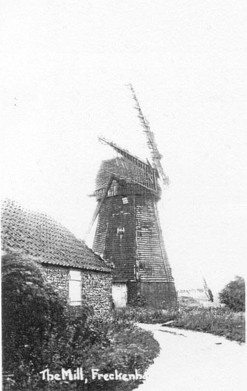
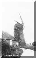 A
bit further on and we come to one of Freckenham's two windmills. Both were smock
mills, built within sight of each other, but on different routes out of the
village, on high ground to catch the prevailing winds. Domesday records
Freckenham as having one mill, but this would have been water or animal powered.
There had been successive wind mills on the Chippenham Road from at least the
early C18. In 1736 it was recorded the mill had lately been demolished and by
1757 a new one had been erected. The last mill on that site was demolished
sometime around 1910, although its base was still being used for storage seventy
years later. This one was on the Fordham Road and was built around 1823. On the
ground floor was an inscription which read: 'THE FIRST GRIST GROUND AT THIS
MILL WAS MR INO (JOHN) NORMAN, FRECKENHAM, JUNE 30TH 1824.' The mill was
demolished in 1967.
A
bit further on and we come to one of Freckenham's two windmills. Both were smock
mills, built within sight of each other, but on different routes out of the
village, on high ground to catch the prevailing winds. Domesday records
Freckenham as having one mill, but this would have been water or animal powered.
There had been successive wind mills on the Chippenham Road from at least the
early C18. In 1736 it was recorded the mill had lately been demolished and by
1757 a new one had been erected. The last mill on that site was demolished
sometime around 1910, although its base was still being used for storage seventy
years later. This one was on the Fordham Road and was built around 1823. On the
ground floor was an inscription which read: 'THE FIRST GRIST GROUND AT THIS
MILL WAS MR INO (JOHN) NORMAN, FRECKENHAM, JUNE 30TH 1824.' The mill was
demolished in 1967.
![Mortimers Lane > Simply click to enlarge... then use the [Back] button to return](images/6_mortimers_lane_small.jpg) Retracing
our steps to the crossroads we turn left into Mortimer's Lane to admire this
charming old cottage. In 1885 a labourer working in his garden uncovered a hoard
of over 90 Icenian gold coins, circa AD 0-25, of a rare or formerly unknown
type. Most of the coins were sold off but the British Museum did manage to
obtain a few. The cottage still stands but the house just visible behind the
trees at right no longer exists. If we were to walk down to the end of
Mortimer's land and follow the track we would pass the site of a moat, once a 5
metre ditch surrounding a 30 metre platform, but now ploughed out, and
eventually reach the Isleham Road. If we were to turn right and right again we
could return to the village via a parallel track leading into North Street. This
used to be a pleasant circular walk until a few years ago until, for some
unexplained reason, the landowner refused to allow access to the paths. Both
paths were once, prior to parliamentary enclosure in 1824, important
thoroughfares leading to the River, the fens, Beck Common and Beck Bridge, the
Chapel of the Blessed Mary and the headlands to the open fields.
Retracing
our steps to the crossroads we turn left into Mortimer's Lane to admire this
charming old cottage. In 1885 a labourer working in his garden uncovered a hoard
of over 90 Icenian gold coins, circa AD 0-25, of a rare or formerly unknown
type. Most of the coins were sold off but the British Museum did manage to
obtain a few. The cottage still stands but the house just visible behind the
trees at right no longer exists. If we were to walk down to the end of
Mortimer's land and follow the track we would pass the site of a moat, once a 5
metre ditch surrounding a 30 metre platform, but now ploughed out, and
eventually reach the Isleham Road. If we were to turn right and right again we
could return to the village via a parallel track leading into North Street. This
used to be a pleasant circular walk until a few years ago until, for some
unexplained reason, the landowner refused to allow access to the paths. Both
paths were once, prior to parliamentary enclosure in 1824, important
thoroughfares leading to the River, the fens, Beck Common and Beck Bridge, the
Chapel of the Blessed Mary and the headlands to the open fields.
![The School > Simply click to enlarge... then use the [Back] button to return](images/8_the_school_small.jpg) Back
to the crossroads once more and a right turn takes us into Chippenham Road and
Freckenham School, a national school built in 1840 at a cost of £120. The
school was closed in 1970 and the building converted to a private house. The
Golden Boar can be seen across the river to the right, to its left is the row of
cottages with the crooked chimney which we saw at the start of our tour.
Back
to the crossroads once more and a right turn takes us into Chippenham Road and
Freckenham School, a national school built in 1840 at a cost of £120. The
school was closed in 1970 and the building converted to a private house. The
Golden Boar can be seen across the river to the right, to its left is the row of
cottages with the crooked chimney which we saw at the start of our tour.
![The Meadows > Simply click to enlarge... then use the [Back] button to return](images/9_the_meadows_small.jpg) Beyond
the school we come the Lee Brook and a view over the water meadows to the
Church. Here we can see the ditches and diverted watercourse which facilitated
the creation of a 'floated' water meadow. Artificial irrigation of the ground in
winter prevented frost penetration, raised the temperature and so stimulated the
growth of grass. It worked by a leat which 'fed water into channels running
along the top of parallel ridges, superificially resembling the "ridge and
furrow" of former arable fields. It flowed smoothly down the sides of these
and into drains (located in the "furrows") which returned the water to
the river.' Sheep were turned out to enjoy the early grazing and when they were
moved onto summer pastures the meadow was reflooded and produced a substantial
second growth which was cut for hay. This increase in animal feed encouraged
larger flocks which resulting in more manure for the fields which in turn
increased arable yields. It was the adoption of such innovative techniques that
was so crucial to the succes of the 'agricultural revolution'. Terriers and
surveys from as early as 1699 call this meadow Trenchers or The Trenches which
would place this as one of the earliest examples of a 'floating' in the region,
as the technique was not widely adopted in East Anglia until the end of the 18th
century. Most of the ditches were ploughed out to create the village playing
field, but some can still be seen to the left of the entrance path.
Beyond
the school we come the Lee Brook and a view over the water meadows to the
Church. Here we can see the ditches and diverted watercourse which facilitated
the creation of a 'floated' water meadow. Artificial irrigation of the ground in
winter prevented frost penetration, raised the temperature and so stimulated the
growth of grass. It worked by a leat which 'fed water into channels running
along the top of parallel ridges, superificially resembling the "ridge and
furrow" of former arable fields. It flowed smoothly down the sides of these
and into drains (located in the "furrows") which returned the water to
the river.' Sheep were turned out to enjoy the early grazing and when they were
moved onto summer pastures the meadow was reflooded and produced a substantial
second growth which was cut for hay. This increase in animal feed encouraged
larger flocks which resulting in more manure for the fields which in turn
increased arable yields. It was the adoption of such innovative techniques that
was so crucial to the succes of the 'agricultural revolution'. Terriers and
surveys from as early as 1699 call this meadow Trenchers or The Trenches which
would place this as one of the earliest examples of a 'floating' in the region,
as the technique was not widely adopted in East Anglia until the end of the 18th
century. Most of the ditches were ploughed out to create the village playing
field, but some can still be seen to the left of the entrance path.
![Long view of The Street to bridge > Simply click to enlarge... then use the [Back] button to return](images/10_long_view_of_the_street_to_bridge_small.jpg) Returning
to the crossroads we retrace our footsteps along The Street . The third building
on the right is The Reading Room. It was erected in 1894, at the instigation of
Wm. Victor Paley and paid for by subscription, as a place where the men of the
village could congregate and read the freely supplied newspapers, in a bid to
lure them away from the demon drink. It later housed a lending library and by
1908 it was in general use as the Village Hall. Four years ago a new village
hall was built and the old Reading Room was converted into a private house. We
can just make out the old forge on the bridge in the centre of the photograph.
Returning
to the crossroads we retrace our footsteps along The Street . The third building
on the right is The Reading Room. It was erected in 1894, at the instigation of
Wm. Victor Paley and paid for by subscription, as a place where the men of the
village could congregate and read the freely supplied newspapers, in a bid to
lure them away from the demon drink. It later housed a lending library and by
1908 it was in general use as the Village Hall. Four years ago a new village
hall was built and the old Reading Room was converted into a private house. We
can just make out the old forge on the bridge in the centre of the photograph.
![The_bridge and forge > Simply click to enlarge... then use the [Back] button to return](images/11_the_bridge_and_forge_small.jpg) Closer
to the bridge and we get a better view of the old forge. Fourteen Tolworthys
were blacksmiths here from 1844 until 1879, the last named was a Mrs. Susan
Tolworthy but whether she actually wielded the hammer is unclear. The forge went
the way of most of its kind with the demise of the heavy horse and it took to
servicing machinery instead. It was rebuilt as a two pump garage when the bridge
was demolished in 1954. In the centre is the Golden Boar, a sixteenth century
timber framed building with a brick skin and later additions. It is one of the
oldest buildings in the village. Recent refurbishment to the fireplace uncovered
three large dressed limestone blocks, decorated with armorial bearings, which
were probably taken from a church or an altar tomb. The stones may have come
from a medieval chantry or pilgrim's chapel which existed between the 12th and
the 16th centuries but disappeared from documentary sources at about the time
the Boar was built.
Closer
to the bridge and we get a better view of the old forge. Fourteen Tolworthys
were blacksmiths here from 1844 until 1879, the last named was a Mrs. Susan
Tolworthy but whether she actually wielded the hammer is unclear. The forge went
the way of most of its kind with the demise of the heavy horse and it took to
servicing machinery instead. It was rebuilt as a two pump garage when the bridge
was demolished in 1954. In the centre is the Golden Boar, a sixteenth century
timber framed building with a brick skin and later additions. It is one of the
oldest buildings in the village. Recent refurbishment to the fireplace uncovered
three large dressed limestone blocks, decorated with armorial bearings, which
were probably taken from a church or an altar tomb. The stones may have come
from a medieval chantry or pilgrim's chapel which existed between the 12th and
the 16th centuries but disappeared from documentary sources at about the time
the Boar was built.
![The Lee Brook towards Church > Simply click to enlarge... then use the [Back] button to return](images/12_the_lee_brook_towards_church_small.jpg) We
rest for a moment on the bridge and admire the view of the church. Once a
favourite spot for villagers to gather and gossip on the long summer evenings.
The earthworks on Castle Mound are visible to our left. The River Kennet, which
divides the county boundary, becomes the Lee Brook on entering Suffolk. Now
merely a stream, it meanders through the village to join the River Lark on
Freckenham's northern boundary, but once they were both major East Anglian
rivers, the latter navigable inland to Bury St Edmunds and seawards via the Ouse
and Lynn and vital to the economy of the parish. Swimming in the Brook (still
deep enough forty years ago) was another pastime enjoyed by the village.
We
rest for a moment on the bridge and admire the view of the church. Once a
favourite spot for villagers to gather and gossip on the long summer evenings.
The earthworks on Castle Mound are visible to our left. The River Kennet, which
divides the county boundary, becomes the Lee Brook on entering Suffolk. Now
merely a stream, it meanders through the village to join the River Lark on
Freckenham's northern boundary, but once they were both major East Anglian
rivers, the latter navigable inland to Bury St Edmunds and seawards via the Ouse
and Lynn and vital to the economy of the parish. Swimming in the Brook (still
deep enough forty years ago) was another pastime enjoyed by the village.
![Church Lane > Simply click to enlarge... then use the [Back] button to return](images/13_church_lane_small.jpg) Returning
to The Pound we bear right into Church Lane. The church, rectory, manor house
and several fine old houses are clustered together above the village within the
safety of the castle confines. This part of the village was formerly known as
Church Square. The house on the left was once a substantial gentleman's
residence but by the time of this photograph had been converted to house five
village families. This and its neighbour are distinguished by decorative
bargebording. Sadly both these beautiful buildings have been demolished and
replaced with modern houses.
Returning
to The Pound we bear right into Church Lane. The church, rectory, manor house
and several fine old houses are clustered together above the village within the
safety of the castle confines. This part of the village was formerly known as
Church Square. The house on the left was once a substantial gentleman's
residence but by the time of this photograph had been converted to house five
village families. This and its neighbour are distinguished by decorative
bargebording. Sadly both these beautiful buildings have been demolished and
replaced with modern houses.
![The Rectory > Simply click to enlarge... then use the [Back] button to return](images/15_the_rectory_small.jpg) This
imposing building is the rectory. The rear range has a timber framed core dating
from the late 16th century, the main body dates from the mid 18th century, and
it was enlarged and improved in the early 19th century. Successive incumbents
have spent considerable sums on its improvement: in 1699 Benjamin Castell
(1696-1705) spent £120 or 'three years income or four upon the vicarage house',
between 1760 and 1765 Michael Smith D.D. (1760-1773) spent over £640 on
building the north front and essential repairs, Henry Bates (1773-1816) built
'the small study or wing on the North Front' and in 1829 Samuel Tilbrooke spent
£1,180 on 'the whole of the South Front and the offices', including £104 on
plumbing, £65 on wallpapering the rooms and 16 guineas for the installation of
a kitchen range. When the church commissioners sold the rectory in the 1970s one
of the wings was demolished to make it more convenient for modern living.
This
imposing building is the rectory. The rear range has a timber framed core dating
from the late 16th century, the main body dates from the mid 18th century, and
it was enlarged and improved in the early 19th century. Successive incumbents
have spent considerable sums on its improvement: in 1699 Benjamin Castell
(1696-1705) spent £120 or 'three years income or four upon the vicarage house',
between 1760 and 1765 Michael Smith D.D. (1760-1773) spent over £640 on
building the north front and essential repairs, Henry Bates (1773-1816) built
'the small study or wing on the North Front' and in 1829 Samuel Tilbrooke spent
£1,180 on 'the whole of the South Front and the offices', including £104 on
plumbing, £65 on wallpapering the rooms and 16 guineas for the installation of
a kitchen range. When the church commissioners sold the rectory in the 1970s one
of the wings was demolished to make it more convenient for modern living.
![The Church > Simply click to enlarge... then use the [Back] button to return](images/16_the_church_small.jpg) We
end our stroll around Freckenham with a visit to St. Andrew's church, seen here
from the Rectory lawn. This lovely old building was built between the 13th and
14th centuries in Barnack stone and flint, with a chancel, nave, north aisle and
chapel. The west tower was added in the 15th century. The Rev. George Paley
undertook substantial repairs and alterations in 1867-9, including rebuilding
the south porch. The thatch was replaced with in 1870 and the tower rebuilt in
1884, two years after it collapsed, thankfully without causing other damage or
injury. Its bench ends are interesting illustrations of the medieval
woodcarver's art, including a lady telling her beads, a pelican in her piety, a
devil thrusting sinner into the jaws of hell (a monster). On the north wall is a
curious 15th century alabaster plaque of St. Eligius shoeing a horse. The full
beauty of the church can be appreciated during Freckenham's annual flower
festival.
We
end our stroll around Freckenham with a visit to St. Andrew's church, seen here
from the Rectory lawn. This lovely old building was built between the 13th and
14th centuries in Barnack stone and flint, with a chancel, nave, north aisle and
chapel. The west tower was added in the 15th century. The Rev. George Paley
undertook substantial repairs and alterations in 1867-9, including rebuilding
the south porch. The thatch was replaced with in 1870 and the tower rebuilt in
1884, two years after it collapsed, thankfully without causing other damage or
injury. Its bench ends are interesting illustrations of the medieval
woodcarver's art, including a lady telling her beads, a pelican in her piety, a
devil thrusting sinner into the jaws of hell (a monster). On the north wall is a
curious 15th century alabaster plaque of St. Eligius shoeing a horse. The full
beauty of the church can be appreciated during Freckenham's annual flower
festival.
© Sandie Geddes, 2000.
Photographs from the collections of Kay Gee & Ann Lister


![The Pound > Simply click to enlarge... then use the [Back] button to return](images/1_the_pound.jpg)
![The Signpost > Simply click to enlarge... then use the [Back] button to return](images/2_signpost.jpg)
![The Bell > Simply click to enlarge... then use the [Back] button to return](images/4_the_bell.jpg)
![Cottage and caravan > Simply click to enlarge... then use the [Back] button to return](images/5_cottage_and_caravan.jpg)
![Wesleyan Chapel > Simply click to enlarge... then use the [Back] button to return](images/7_wesleyan_chapel.jpg)
![Mortimers Lane > Simply click to enlarge... then use the [Back] button to return](images/6_mortimers_lane.jpg)
![The School > Simply click to enlarge... then use the [Back] button to return](images/8_the_school.jpg)
![The Meadows > Simply click to enlarge... then use the [Back] button to return](images/9_the_meadows.jpg)
![Long view of The Street to bridge > Simply click to enlarge... then use the [Back] button to return](images/10_long_view_of_the_street_to_bridge.jpg)
![The_bridge and forge > Simply click to enlarge... then use the [Back] button to return](images/11_the_bridge_and_forge.jpg)
![The Lee Brook towards Church > Simply click to enlarge... then use the [Back] button to return](images/12_the_lee_brook_towards_church.jpg)
![Church Lane > Simply click to enlarge... then use the [Back] button to return](images/13_church_lane.jpg)
![The Rectory > Simply click to enlarge... then use the [Back] button to return](images/15_the_rectory.jpg)
![The Church > Simply click to enlarge... then use the [Back] button to return](images/16_the_church.jpg)