


| |
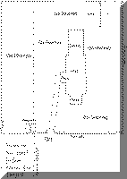
The Graveyard of St. Mary the Virgin, Santon Downham
 Contrary
to common practice the graveyard of St Mary the Virgin has the largest side on
the North of the church. This includes area D, a large
new (1964) graveyard and cremation plots marked A. Areas
B, C and E
are all in the old graveyard around the church. Many of the graves are obscure
through weathering, but those that can be read indicate a settled community into
which has come a steady influx of new comers . The earliest graves are of
prosperous yeomen their estate workers and their servants. The survey
dates from 1813 to the present day. Many of the graves are unmarked. The Santon
Downham Index of Burials from 1813 to 2000 is included. It has been modified to
show the plot numbers in the five different areas of the churchyard. Contrary
to common practice the graveyard of St Mary the Virgin has the largest side on
the North of the church. This includes area D, a large
new (1964) graveyard and cremation plots marked A. Areas
B, C and E
are all in the old graveyard around the church. Many of the graves are obscure
through weathering, but those that can be read indicate a settled community into
which has come a steady influx of new comers . The earliest graves are of
prosperous yeomen their estate workers and their servants. The survey
dates from 1813 to the present day. Many of the graves are unmarked. The Santon
Downham Index of Burials from 1813 to 2000 is included. It has been modified to
show the plot numbers in the five different areas of the churchyard.
Ronnie Moran ©2000
 
 
  |